Hurricanes
Hurricanes are triple threat storms. They pound communities with wind and tornadoes, flood the area with torrential rain, then sweep away what's left with devastating storm surges.
They go by different names, depending on where they appear. If they form over the North Atlantic Ocean and Northeast Pacific, we call them hurricanes. In the South Pacific and Indian Ocean, they're called cyclones, and over the Northwest Pacific Ocean, they're known as typhoons. Three different names, but they're all the same deadly event.
Even with modern weather satellites and improved construction methods, the death and destruction can be immense. In 2008 cyclone Nargis hit Asia and killed more than 140,000 people. Hurricane Maria in 2017 killed more than 3,000 people, and hurricane Dorian in 2019 left 70,000 people homeless.
Hurricanes start small, forming a tropical disturbance or depression. They draw their energy from warm ocean waters, so they're strongest over or near water. If they drift into cooler waters or hit land, they rapidly weaken and dissipate. That means coastal areas and islands in the ocean are particularly vulnerable to these storms.
As a hurricane spins, the wind speed increases, and eventually, they develop their distinguishing eye. Storms can range from 100 to over 2,000 kilometers in diameter.
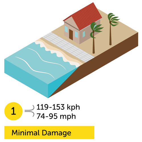
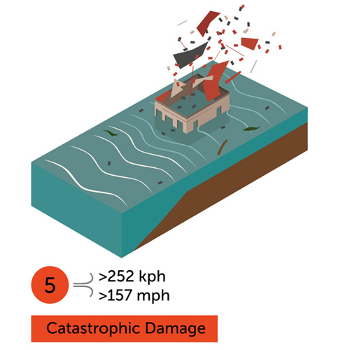
To prepare communities in their path, forecasters in the United States rank hurricanes on a scale from 1 to 5, with a category five storm designated as a "Major Hurricane." Following is a chart showing the various designations used around the world.
National Hurricane Center and Central Pacific Hurricane Center
Joint Typhoon Warning Center
Japan Meteorological Agency
Beaufort scale |
1-minute sustained winds |
10-minute sustained winds |
NE Pacific & N Atlantic |
NW Pacific |
NW Pacific |
|---|---|---|---|---|---|
| 0–7 | <32 knots (37 mph; 59 km/h) | <28 knots (32 mph; 52 km/h) | Tropical Depression | Tropical Depression | Tropical Depression |
| 7 | 33 knots (38 mph; 61 km/h) | 28–29 knots (32–33 mph; 52–54 km/h) | |||
| 8 | 34–37 knots (39–43 mph; 63–69 km/h) | 30–33 knots (35–38 mph; 56–61 km/h) | Tropical Storm | Tropical Storm | |
| 9–10 | 38–54 knots (44–62 mph; 70–100 km/h) | 34–47 knots (39–54 mph; 63–87 km/h) | Tropical Storm | ||
| 11 | 55–63 knots (63–72 mph; 102–117 km/h) | 48–55 knots (55–63 mph; 89–102 km/h) | Severe Tropical Storm |
||
| 12+ | 64–71 knots (74–82 mph; 119–131 km/h) | 56–63 knots (64–72 mph; 104–117 km/h) | Category 1 Hurricane |
Typhoon | |
| 72–82 knots (83–94 mph; 133–152 km/h) | 64–72 knots (74–83 mph; 119–133 km/h) | Typhoon | |||
| 83–95 knots (96–109 mph; 154–176 km/h) | 73–83 knots (84–96 mph; 135–154 km/h) | Category 2 Hurricane |
|||
| 96–97 knots (110–112 mph; 178–180 km/h) | 84–85 knots (97–98 mph; 156–157 km/h) | Category 3 Major Hurricane |
Very Strong Typhoon | ||
| 98–112 knots (113–129 mph; 181–207 km/h) | 86–98 knots (99–113 mph; 159–181 km/h) | ||||
| 113–122 knots (130–140 mph; 209–226 km/h) | 99–107 knots (114–123 mph; 183–198 km/h) | Category 4 Major Hurricane |
|||
| 123–129 knots (142–148 mph; 228–239 km/h) | 108–113 knots (124–130 mph; 200–209 km/h) | Violent Typhoon | |||
| 130–136 knots (150–157 mph; 241–252 km/h) | 114–119 knots (131–137 mph; 211–220 km/h) | Super Typhoon |
|||
| >136 knots (157 mph; 252 km/h) | >120 knots (138 mph; 222 km/h) | Category 5 Major Hurricane |
India Meteorological Department
Météo-France
Bureau of Meteorology
Fiji Meteorological Service
Beaufort scale |
1-minute sustained winds |
10-minute sustained winds |
N Indian Ocean |
SW Indian Ocean |
Australia & S Pacific |
|---|---|---|---|---|---|
| 0–7 | <32 knots (37 mph; 59 km/h) | <28 knots (32 mph; 52 km/h) | Depression | Zone of Disturbed Weather | Tropical Disturbance |
| 7 | 33 knots (38 mph; 61 km/h) | 28–29 knots (32–33 mph; 52–54 km/h) | Deep Depression | Tropical Disturbance | Tropical Depression |
| 8 | 34–37 knots (39–43 mph; 63–69 km/h) | 30–33 knots (35–38 mph; 56–61 km/h) | Tropical Depression | Tropical Low | |
| 9–10 | 38–54 knots (44–62 mph; 70–100 km/h) | 34–47 knots (39–54 mph; 63–87 km/h) | Cyclonic Storm | Moderate Tropical Storm |
Category 1 Tropical Cyclone |
| 11 | 55–63 knots (63–72 mph; 102–117 km/h) | 48–55 knots (55–63 mph; 89–102 km/h) | Severe Cyclonic Storm |
Severe Tropical Storm |
Category 2 Tropical Cyclone |
| 12+ | 64–71 knots (74–82 mph; 119–131 km/h) | 56–63 knots (64–72 mph; 104–117 km/h) | |||
| 72–82 knots (83–94 mph; 133–152 km/h) | 64–72 knots (74–83 mph; 119–133 km/h) | Very Severe Cyclonic Storm |
Tropical Cyclone | Category 3 Severe Tropical Cyclone |
|
| 83–95 knots (96–109 mph; 154–176 km/h) | 73–83 knots (84–96 mph; 135–154 km/h) | ||||
| 96–97 knots (110–112 mph; 178–180 km/h) | 84–85 knots (97–98 mph; 156–157 km/h) | ||||
| 98–112 knots (113–129 mph; 181–207 km/h) | 86–98 knots (99–113 mph; 159–181 km/h) | Extremely Severe Cyclonic Storm |
Intense Tropical Cyclone |
Category 4 Severe Tropical Cyclone |
|
| 113–122 knots (130–140 mph; 209–226 km/h) | 99–107 knots (114–123 mph; 183–198 km/h) | ||||
| 123–129 knots (142–148 mph; 228–239 km/h) | 108–113 knots (124–130 mph; 200–209 km/h) | Category 5 Severe Tropical Cyclone |
|||
| 130–136 knots (150–157 mph; 241–252 km/h) | 114–119 knots (131–137 mph; 211–220 km/h) | Super Cyclonic Storm |
Very Intense Tropical Cyclone |
||
| >136 knots (157 mph; 252 km/h) | >120 knots (138 mph; 222 km/h) |
Hurricanes 101 | National Geographic
Hurricanes are the most powerful storms known to man. Find out when hurricane season peaks, how the storms form, and the surprising role they play in the larger global ecosystem.
How do Hurricanes form? - why are Hurricanes extremely dangerous?
This is what the damage looks like.


Hebert Box
Paul Hebert was a forecaster that worked for the National Weather Service and National Hurricane Center. In the late 1970s, he noticed that most strong hurricanes, with winds exceeding 110 miles per hour, had passed through one of these two small square geographic regions.
The first Hebert Box is located east of Puerto Rico over the US Virgin Islands, between 15° and 20° north latitude and 60° to 65° west longitude. The second Hebert Box is located over the Cayman Islands between 15° and 20° north latitude and 80° to 85° west longitude.
Geography is key to the Hebert Boxes' predictive abilities. If a hurricane goes through one of the Hebert Boxes, the storm has plenty of space to intensify before striking Florida. Prevailing winds from those regions in the world also tend to push storms in Florida's direction. When a hurricane passes outside a Hebert Box, it's either too close to land to intensify much, or it's far enough from land that steering winds and other atmospheric conditions tend to push it away from Florida.
Keep in mind that a hurricane does NOT have to pass through one of these boxes to strike Florida. Also, a hurricane that DOES pass through can still miss Florida. What you should take away from this is that if you live in Florida and a hurricane passes through one of these boxes, you should pay very close attention to where it's headed.

Source: Modification of map from Wiki Commons by uploader - Author: J Cricket - Link: https://commons.wikimedia.org/wiki/File:Hebert_boxes.jpg
Present and Future Threats
Over the last 30 years, hurricanes are getting stronger three times faster than they used to, making it harder for forecasters to know how dangerous they'll be until after they start to hit communities.
Cities close to the ocean are growing, which means more people will be at risk when these storms strike. Evacuation routes will have more people, shelters will be packed, and emergency services will have more to deal with. As climate change continues, these storms will only grow larger, more intense and more destructive.
Real-time Information
The single best site we've found for real-time information on Atlantic hurricanes is Track the Tropics: http://www.trackthetropics.com/
Here are additional hurricane tracking sites.
Preparation - Survival
Click Here for information on what to do from the United States government website, Ready.gov.
Click Here for the Red Cross Hurricane Safety Information.
Click Here for the Disaster Safety information on Hurricanes from the Insurance Institute for Business & Home Safety.
Click Here to download a PDF file with information on what to do from the United States government website, Ready.gov.

Return to 101 Ways to Die Home Page
This information is presented to make people aware of the larger world around them. If you can prepare for something as devastating as this, you're much more likely to be ready for smaller disruptions. Be aware and prepare.
6/6/2020
Updated 4/15/2021
Updated 5/31/2021